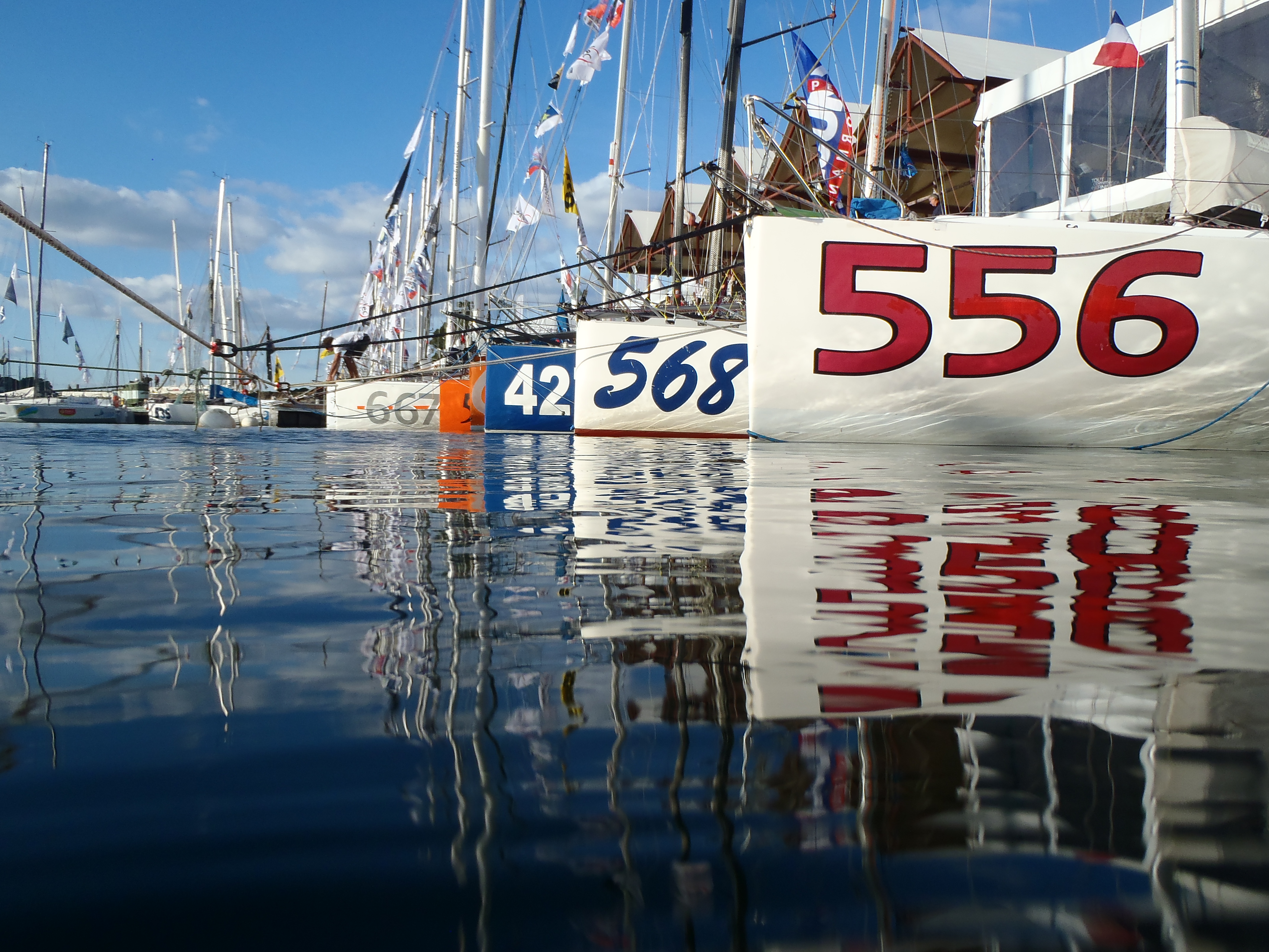
Mini Transat 2013 Race Village in Douarnenez
Last week I sailed from Lorient to Douarnenez to watch the start of the Mini Transat from the water. I was joined by 2011 Transat finisher Björn Freels.
Unhappily due to the weather the start was postponed but that gave us the opportunity to join Henrik Masekowitz on his proto 625 for the parade and to take pictures and shoot some video.
These are some of the impressions, the videos still remain to be cut.


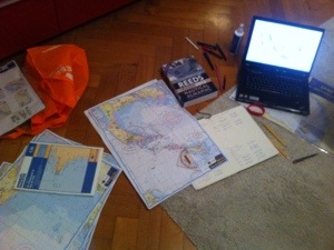
chartwork on a mini
Due to medical reasons I am not allowed to train right now (although luckily that ban is not for long any more) I am spending time preparing the season.
After having spliced the new parts of the running rigging (some new halyards, new sheets) and TEEM took care of the electronics on board I have time for some race prep – at least those bits that can be done at home.
A specialty of sailing a mini is that we aren’t allowed to carry GPS plotters with electronic seacharts so our GPS systems are only allowed to display positions and waypoints/routes.
If you consider that and the fact that I am dumbed down by sleep deprivation to a en extreme level of stupidity then you’ll understand that I try to prepare my seacharts idiot-proof.
My preparation looks about like this:
1. General waypoints
I’ll go through my paper seacharts and mark waypoints with a permanent pen, then I note those coordinates in a GPS waypoint manager on my laptop. I also write the waypoint with some additional notes into a separate list.
Every waypoint is identified by a 5 character code (the gps doesn’t allow more) so the waypoint “GLN_S” is the southern cardinal bouy of the Iles de Glenan.
The waypoints that I mark in this phase are important turning points, entry and exit points of narrow channels or shallows.
If an area is very complex then I try to plan possible ways to cross these waters and create “chains” of waypoints that I can later use as a route to get through that area. I will also write down the maximum allowed cross track error (XTE) for the way from one waypoint to the other. If the chart is very complex I also shade some areas on the paperchart so that at 4am when I look at those charts I understand what my original plan was.
All of these waypoints (overall about a hundred) are then uploaded from the Waypoint manager on my laptop to the GPS on board.
2. Laminate the charts
After the paper charts are prepared I laminate them to make them waterproof. This is great as I can then use them in the cockpit in rain or when we’re getting firehosed.
I take notes on the charts during the races with permanent markers which can be erased. That works great even with wet or salty charts.
3. Roadbook
The next step is to create a roadbook for each race.
The roadbook contains a general planning of the race course and its different stages. A possible stage could be Stage 2 of the Trophee Marie Agnes Peron: “Pt du Raz to Iles de Glenan.
For each stage I now try to identify how to sail this stage at different weather or tidal situation. For this I read the tidal atlas and general weather and tidal information I can get about a certain area (I use the Reed’s Nautical Almanach), i.e. between Belle-Ile and Ile-de-Quiberon. This step is rather important as due to the fast currents on the french atlantic coast the tide has a huge influence on your tactics, especially in conjunction with the wind.
If I have my (or other’s tracks) from the last year then that’s even better and can be analyzed to see what worked well and what didn’t.
4. The week before the race
About a week before the race I take the roadbook back out. From now on I will get fresh GRIB weather data daily and run them through the computer for a routing. These routings are not very useful yet though as the forecasts tend to become relatively reliable only for the next 48 hours.
I try to have the boat in shape as much as possible in these last two days so I can try to relax, get some sleep and have time to focus on the weather.
In these two days I will compare the two big weather models GFS and ECMWF to see where they differ as they will often predict slightly different front movements or general relocations of the weather systems.
The two models are also loaded into the routing software and I will run a couple of ensemble routings where the computer variies the windspeed, wind direction and boat speed.
If necessary, additional waypoints are programmed into the GPS already.
From now on the roadbook is read frequently to try and remember as much of it as possible.
5. Evening and Morning before the start
On the evening before the start I will usually run my final routings and take notes on possible what-if scenarios. Rough waypoints of the optimal routings are loaded into the GPS with the route for the race course.
The whole route including the waypoint coordinates, course and distance to the next mark, etc. are also printed and added to the roadbook on board.
The weather and routing is checked a final time at about 8am on race day (given that the weather models are ready and time permits). The latest forecasts are printed and if necessary final notes are added.
Before the start I will read the notes for the first stage.
If the preparation was good then the roadbook is a huge help. You can always compare the current situation with the prepared scenarios and adapt your plans as you go.
But the best preparation is no help if you don’t use the material. This happened to me last year where in the heat of the battle I forgot to read my notes on tides and got beat up badly at Ile de Groix and Chaussee de Sein.
Well, I guess these are the first notes I can add to my roadbook already.

My living room is not a sail loft
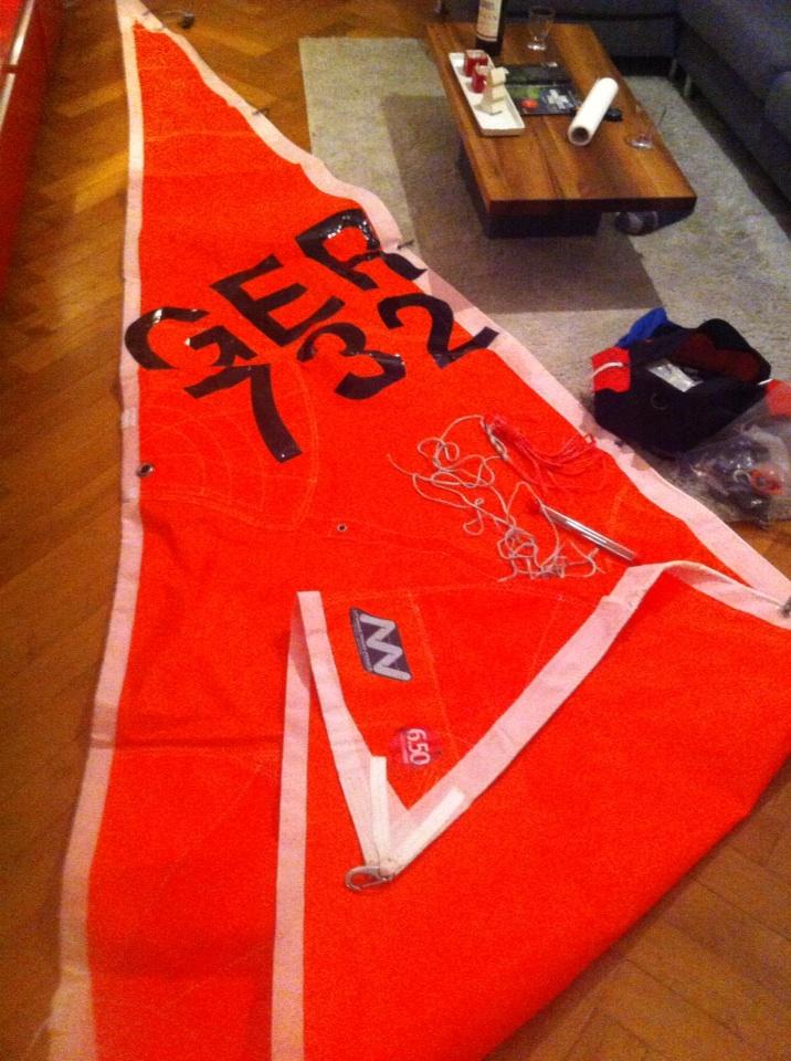 After having had the chance to intensely test out my storm jib during training last november I realized that I needed two dyneema strops to be able to easily and properly attach the storm jib.
One at the head to basically move the luff of the sail further up so when set the halyard is attached at the top of the babystay. This way the halyard can actually tighten the luff instead of just pulling the babystay up.
The other one at the tack to move the tack higher above deck. This way the carts for the genoa sheets can also be used for the storm jib effectively.
While doing that job in my living room I realized the sails don’t actually look that big while on board or in the sail loft so I’m glad I don’t have to carry out any similar work at home on my big solent or my main – that would become really tricky.
Training with Lorient Grand-Large / Tanguy Leglatin
It’s been a bit quiet here the last few months which was due to lack of time but not lack of sailing (luckily).
From october till early december I had the pleasure of participating in the training series organized by Lorient Grand-Large with world-class trainer Tanguy Leglatin.
I benefitted hugely from the training and even though at times it felt like I had to learn sailing from scratch I am sure I could not have figured out in a year what Tanguy taught me in those four weekends.
All the training sessions were doublehanded and I was lucky to find nice and fun crew in Katrina (www.katrinahamracing.com), my buddy Marten and Becky (www.beckyscottracing.com) and Nikki (www.nikkicurwen.com) with the Artemis Offshore Academy.
The weather offered us its full spectrum from absolute calm to 35 knots of wind and rain which allowed us to train our lee trim as well as reefing extensively.
Currently it’s time for boatwork, the seemingly neverending todo-list (and even worse: shopping-list) is starting to get smaller and the missing equipment is arriving as well.
End of january I am going to be back in france to get the boat ready for the new season, some training in february and march and then in april the new season officially begins with the first races of the atlantic coast.
Stay tuned for more news of smaller and larger modifications on board. In the meantime here’s my (first!) sailing video with photos and shots from the training and the 2012 season: